CubeNexus Secures $650K in Pre-Seed Funding to Transform Spatial Data Intelligence
July 1, 2025
by
CubeNexus Inc, a startup uniting spatial data from multiple sources into a single intelligent platform, has raised $650,000 in pre-seed funding. The round was backed by 46 Venture Capital and TitletownTech, signaling strong belief in CubeNexus’ ability to tackle one of today’s most pressing challenges in spatial intelligence - fragmented, siloed data streams.
Co-founded by Steven Brandt and Adam Gobbo, CubeNexus helps industries - from energy to agriculture to defense - make sense of vast amounts of sensor-derived data by offering real-time, high-accuracy spatial data fusion.
What Is CubeNexus Building?
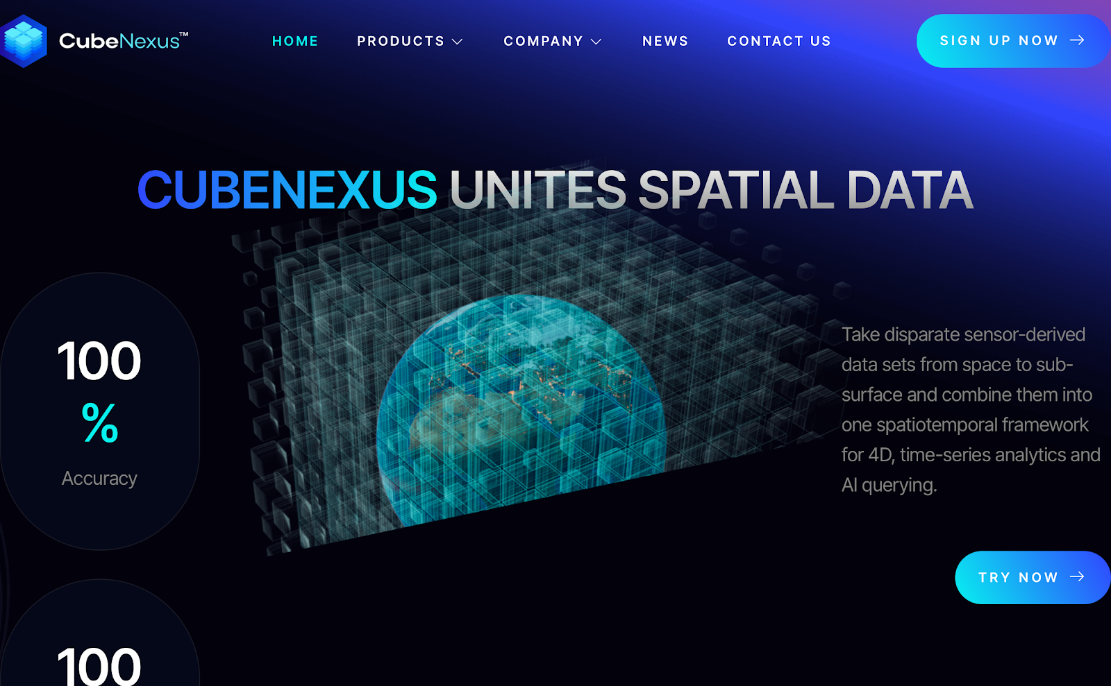
At its core, CubeNexus is building a platform that unites spatial data from various sources - whether satellites, drones, IoT sensors, or subsurface probes - into a coherent, actionable format. Their proprietary system processes this data with 100% accuracy (as claimed on their site) to power a new generation of spatial intelligence for high-impact sectors.
The platform enables companies to extract deeper insights across time and space, building spatiotemporal frameworks that are usable for 4D modeling, scenario analysis, and AI applications. The result? Improved decision-making in areas like:
- Precision agriculture
- Infrastructure monitoring
- Geological exploration
- Disaster response
- National security
Why It Matters Now
The global volume of spatial data - from satellite feeds to underground sensors - is exploding, but most organizations still lack the infrastructure to turn that data into insight. According to Allied Market Research, the geospatial analytics market is expected to reach $209 billion by 2031, growing at a CAGR of 14.6%. But scale without synthesis is useless - companies are collecting more than they can meaningfully analyze.
And this is where the real shift is happening. Startups like CubeNexus are redefining what defensibility actually looks like in deep tech. While most companies focus on gathering more data, CubeNexus is focused on making that data interoperable and intelligent from day one. For founders, this is a critical insight: the long-term edge doesn’t come from hoarding proprietary data - it comes from engineering a system that gets exponentially more useful with every new input, no matter the source. It’s not about owning the most - it’s about connecting the most. That ability to create value through data fusion, not just data capture, is what separates foundational infrastructure plays from short-term features.Why It Matters Now
The global volume of spatial data - from satellite feeds to underground sensors - is exploding, but most organizations still lack the infrastructure to turn that data into insight. According to Allied Market Research, the geospatial analytics market is expected to reach $209.6 billion by 2031, growing at a CAGR of 14.6%. Separately, the remote sensing technologies market is forecasted to exceed $25 billion by 2028, driven by demand in defense, urban planning, and environmental monitoring.
Enterprise use cases are growing more complex: energy companies need better visibility into asset locations, farmers need hyper-local terrain data for smart irrigation, and governments need real-time situational awareness for disaster response. The opportunity is massive - but so is the technical debt in legacy tools and siloed systems.
And this is where the real shift is happening. Startups like CubeNexus are redefining what defensibility actually looks like in deep tech. While most companies focus on gathering more data, CubeNexus is focused on making that data interoperable and intelligent from day one. For founders, this is a critical insight: the long-term edge doesn’t come from hoarding proprietary data - it comes from engineering a system that gets exponentially more useful with every new input, no matter the source. It’s not about owning the most - it’s about connecting the most. That ability to create value through data fusion, not just data capture, is what separates foundational infrastructure plays from short-term features.
How It Works
CubeNexus tackles the hard problem of aligning and unifying disparate spatial datasets, including data from satellites, drones, IoT sensors, and underground probes.
Their platform:
- Normalizes inputs from different formats and spatial scales
- Fuses data in real time using AI-powered alignment models
- Delivers a coherent spatiotemporal view that can be queried, modeled, and visualized
Unlike traditional GIS tools built for static maps, CubeNexus is engineered for dynamic, real-time spatial intelligence across both 2D and 4D environments.
Backed by Strategic Investors
The $650K round was backed by:
- 46 Venture Capital, a firm supporting early-stage technical teams in the Midwest
- TitletownTech, a venture studio created by the Green Bay Packers and Microsoft
Their investment reflects not only belief in the CubeNexus team, but in the critical infrastructure role spatial data platforms will play in the next wave of industrial digitization.
How It Works
CubeNexus takes on the difficult task of aligning and unifying disparate spatial datasets. This includes data from various layers - surface, subsurface, aerial, and orbital - and from diverse sources like satellites, drones, sensors, and field devices.
Their platform:
- Normalizes inputs from different formats and sources
- Fuses data in real-time with AI-powered spatial alignment
- Outputs usable models that support predictive and reactive decision-making
Unlike static GIS tools, CubeNexus is designed for real-time, dynamic use cases - where accuracy, context, and temporal awareness are non-negotiable.
Backed by Strategic Investors
The funding round was supported by:
- 46 Venture Capital, backing startups focused on technical innovation
- TitletownTech, a Microsoft–Green Bay Packers joint venture focused on frontier tech
The support validates CubeNexus not just as a promising product, but as a category-defining company in a fast-emerging market.
Spatial Intelligence Is Becoming Infrastructure
From wildfire prediction to autonomous vehicles and climate monitoring, the demand for live, contextual spatial data is growing across every industry. But current workflows are broken - too many companies rely on disconnected data streams and outdated maps to make high-stakes decisions.
CubeNexus is bridging that gap with a flexible, AI-enhanced platform that makes spatial data continuous, accurate, and unified. Whether you’re optimizing a power grid or planning emergency response routes, the ability to work from a fused, reliable spatial layer can define operational success - or failure.
What’s Next for CubeNexus
The company plans to:
- Expand its engineering and AI research teams
- Roll out industry-specific pilot programs in energy, defense, and agtech
- Launch developer-facing APIs to power third-party spatial tools
- Strengthen partnerships with government and enterprise data providers
As more real-world systems come online and begin generating spatial inputs, CubeNexus is laying the foundation to interpret them in real time, across all layers of earth and sky.
Related Articles

Latest Rounds
November 30, 2025 by 
EcoG Raises $18.57M to Accelerate the Operating System for the Global EV Charging Economy
EcoG has raised $18,573,280 in new funding, led by GET Fund with participation from Extantia Capital and Bayern Kapital. Founded...
Read More
Latest Rounds
November 30, 2025 by
Tidalwave Raises $22M Series A to Build the Infrastructure Layer Modern Homebuilders Need for AI-Driven Operations
Tidalwave has raised $22,000,000 in their Series A, led by Permanent Capital with participation from D.R. Horton, Inc. and Engineering...
Read More
Latest Rounds
November 30, 2025 by
WellBeam Raises $10M to Unify Care Coordination Across the Entire Patient Journey
WellBeam Inc. has secured $10 million in Series A funding, marking a major step toward fixing one of the most...
Read More
Latest Rounds
November 30, 2025 by
Automat Raises $15.5M to Redefine Industrial Automation With Adaptive AI
Automat has secured $15.5 million in Series A funding, a major milestone for a company working to radically transform how...
Read More
Latest Rounds
November 30, 2025 by
Poly Raises $8M to Reinvent How People Organize, Search, and Think With Their Files
Poly (US) has closed an $8,000,000 Seed round, marking a decisive moment for one of the most ambitious productivity startups...
Read More
Latest Rounds
November 30, 2025 by
Voio Raises $8.6M to Power AI That Understands Patients as Individuals, Not Data Points
Voio has secured $8.6 million in Seed funding, marking a major step forward for a company working to bring true...
Read More
Latest Rounds
November 30, 2025 by
Ember Raises $4.3M to Reinvent AI-Driven Revenue Cycle Management for Healthcare Providers
Ember has secured $4.3 million in Seed funding, marking a major step toward transforming one of healthcare’s most expensive, error-prone,...
Read More
Latest Rounds
November 30, 2025 by
Modern Life Raises $20M to Redefine Life Insurance Infrastructure With AI-Powered Tools for Advisors
Modern Life has secured $20 million in new funding, marking another major milestone in its mission to rebuild the fractured,...
Read More
Latest Rounds
November 30, 2025 by
Ampersand Raises $80M to Power the Next Era of High-Performance Materials
Ampersand has secured a major $80 million Series A round, positioning itself as one of the most significant deep-tech companies...
Read More
Latest Rounds
November 30, 2025 by
OpenHands Raises $18.8M to Bring Autonomous Coding Agents Into the Enterprise
OpenHands has raised $18.8 million in Series A funding, marking one of the strongest signals yet that autonomous software development...
Read More